Campaign for the protection and renaturalization of riparian buffers
In order to contribute to the protection of waterways, lakes and wetlands on its territory, the Town of Sutton's Urban and Land-Use Planning Department will conduct visits to shoreline properties in 2023 to verify the condition of riparian buffer strips.

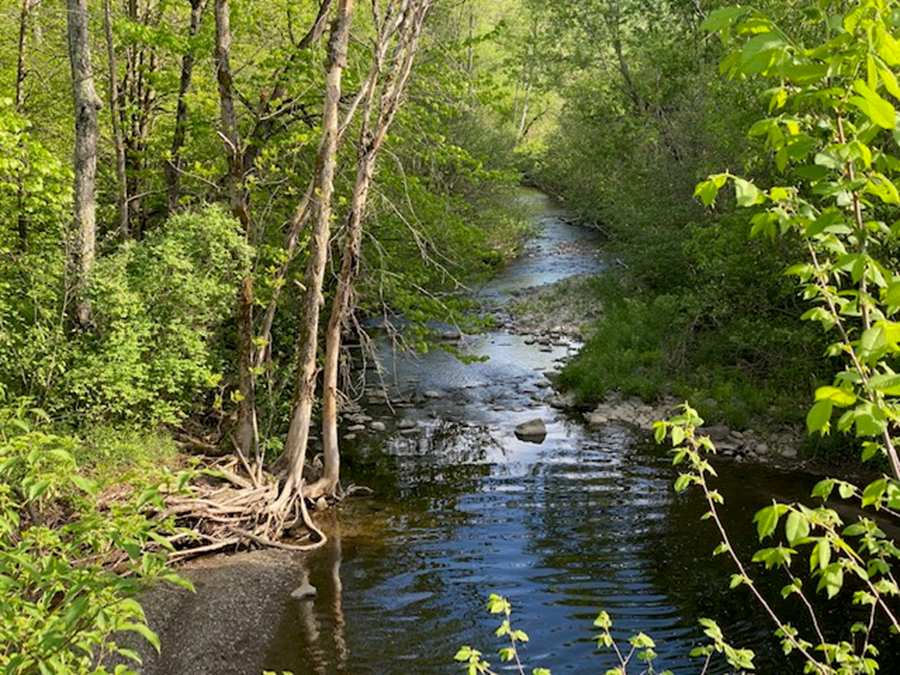
Riparian buffers are strips of natural, permanent vegetation that border lakes, streams and wetlands and extend inland. They are particularly important on small, intermittent streams, or at the head of a watershed, as the sum of these drains a large mass of water, carries the bulk of the pollutant load, and is where the riparian buffer is most effective.
Width of the shoreline
The width of the shoreline is measured horizontally from the high water mark.
The shoreline has a minimum width of ten (10) metres:
- where the slope is less than 30%, or;
- where the slope is greater than 30% and the slope is less than five (5) metres in height.
The shoreline has a minimum of fifteen (15) metres :
- when the slope is continuous and greater than 30%; or
- when the slope is greater than 30% and presents a slope of more than five (5) metres in height;
- on any new subdivision of land leading to the creation of one or more lots made after May 29, 2015;
- for any watercourse located outside the urban perimeter
Riparian buffer regulation applies to:
Lakes:
- All natural lakes;
- Artificial lakes fed by a watercourse;
- Artificial lakes not fed by a watercourse whose depth is 2 metres or more (MELCCFP criteria).
To watercourses :
- Regular flow;
- Intermittent flow, which are dry for part of the year.
Wetlands:
- 0.5 hectares or more;
- All riparian wetlands, regardless of whether or not they are fed by stream overflow.
Shoreline protection
All constructions, structures and works are prohibited on the shoreline, with the exception of certain elements listed in the zoning by-law and which require authorization from the City and/or the MELCCFP.
Prohibition of grass cutting and shoreline revegetation
The shoreline of any waterfront property shall, for its entire width, remain in its natural state or be revegetated.
The mowing of grass, the creation of flower beds, the addition of soil, compost or fertilizer and the deposit of any plant or other waste are prohibited.
For any shoreline property where the shoreline was already grassed or artificialized prior to 2015, the prohibition on grass cutting applies to a minimum 3 metres wide shoreline strip, which must remain in its natural state or be revegetated.
Where a structure has been legally erected in whole or in part within the shoreline, vegetation maintenance, including grass cutting, is permitted within a 1 metre band around the walls.
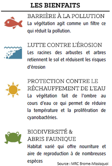
Why stop mowing the grass at the water’s edge? Because a grass bank does not stabilize the banks sufficiently, does not act as a filter or barrier to pollution, and does not provide shade and shelter for wildlife.
Riparian buffers in agricultural land
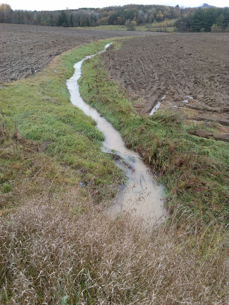
[Photo: example of a bad riparian buffer]
On land where active agriculture is practiced, the riparian buffer is 2 metres at the top of the slope. At a minimum, it must be 3 metres from the high water mark. Plowing, tilling, fertilizing or applying pesticides in this strip is prohibited.
Cutting of herbaceous vegetation is permitted when the slope of the bank is less than 30% and only on the top of the slope when the slope is greater than 30%.
It is forbidden to allow free access of farm animals to watercourses and water bodies, including horses. A fence must be placed at least 2 metres from the top of the slope to prevent access. A controlled waterway crossing may however be provided.
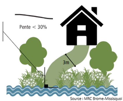
The construction of a path or a staircase
When the slope of the bank is less than 30%:
- the maximum width of the pathway right-of-way is 3 metres and the maximum width of the stairway is 1.5 metres;
- the pathway leading to the access shall not be perpendicular to the shoreline;
- at the edge of the water body, within the first 5 metres from the high water mark, the access may be constructed perpendicular to the shoreline to minimize the removal of shrub or tree species;
- the soil in the right-of-way of the opening shall not be exposed or left bare and shall be covered minimally with herbaceous species.
- la largeur maximale de l’emprise du sentier ou de l’escalier est de 1,5 mètres;
- les travaux doivent être réalisés sans remblai ni déblai;
- l’escalier doit être construit sur pieux ou pilotis et les espèces herbacées ou arbustives doivent être conservées en place;
- le sentier doit être aménagé en biais avec la ligne de rivage en suivant un tracé sinueux qui s’adapte à la topographie du terrain et conçu en utilisant des matériaux perméables (terre battue, gravier ou cailloux, dalles alvéolées, pavés perméables, etc.).
Where the slope of the shoreline is equal to or greater than 30% :
- the maximum width of the right-of-way for the pathway or stairway is 1.5 metres
- the work must be carried out without any fill or excavation
- the stairway must be built on piles or pilings and the herbaceous or shrubby species must be kept in place
- the pathway must be laid out at an angle to the shoreline following a sinuous route that adapts to the topography of the land and designed using permeable materials (clay, gravel or pebbles, honeycombed slabs, permeable pavers, etc.).
For more details on shoreline protection regulation, see Chapter 8: Dispositions relatives à la protection et la mise en valeur de l’environnement, Section 1: Dispositions relatives aux rives et au littoral Sutton Zoning By-law Number 115-2 (in French).
Source: MRC Brome-Missisquoi, Fiche technique sur le contrôle de l’érosion, 1.1 Renaturalisation des berges (in French).